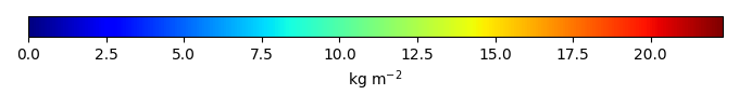
Mean State
Download Data |
Period Mean (original grids) [Pg] |
Model Period Mean (intersection) [Pg] |
Benchmark Period Mean (intersection) [Pg] |
Model Period Mean (complement) [Pg] |
Benchmark Period Mean (complement) [Pg] |
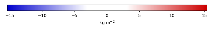
Bias [kg m-2] |
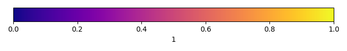
Bias Score [1] |
Spatial Distribution Score [1] |
Overall Score [1] |
|||
|---|---|---|---|---|---|---|---|---|---|---|---|---|
| Benchmark | [-] | 30.1 | ||||||||||
| CABLE-POP | [-] | 444. | 24.9 | 28.6 | 419. | 1.48 | -0.434 | 0.566 | 0.594 | 0.580 | ||
| CARDAMOM | [-] | 408. | 30.6 | 28.9 | 378. | 1.20 | 0.192 | 0.712 | 0.795 | 0.753 | ||
| CLASSIC | [-] | 601. | 34.5 | 29.9 | 564. | 0.184 | 0.501 | 0.583 | 0.858 | 0.721 | ||
| CLM6.0 | [-] | 978. | 46.2 | 30.1 | 922. | 1.67 | 0.616 | 0.872 | 0.744 | |||
| DLEM | [-] | 482. | 18.3 | 29.6 | 464. | 0.521 | -1.27 | 0.594 | 0.493 | 0.544 | ||
| ED | [-] | 343. | 13.5 | 29.6 | 329. | 0.458 | -1.81 | 0.501 | 0.425 | 0.463 | ||
| ELM | [-] | 817. | 41.2 | 29.9 | 769. | 0.176 | 1.21 | 0.613 | 0.810 | 0.711 | ||
| IBIS | [-] | 323. | 19.2 | 29.6 | 304. | 0.533 | -1.18 | 0.604 | 0.517 | 0.560 | ||
| iMAPLE | [-] | 416. | 25.9 | 30.1 | 390. | -0.449 | 0.635 | 0.793 | 0.714 | |||
| ISAM | [-] | 708. | 48.6 | 29.6 | 659. | 0.521 | 2.16 | 0.544 | 0.822 | 0.683 | ||
| ISBA-CTRIP | [-] | 671. | 44.3 | 30.1 | 626. | 0.0121 | 1.54 | 0.545 | 0.805 | 0.675 | ||
| JSBACH | [-] | 374. | 23.0 | 29.0 | 349. | 1.09 | -0.648 | 0.582 | 0.731 | 0.656 | ||
| JULES | [-] | 388. | 14.0 | 30.1 | 374. | 0.00530 | -1.75 | 0.515 | 0.599 | 0.557 | ||
| LPJ-GUESS | [-] | 324. | 16.0 | 29.4 | 308. | 0.698 | -1.54 | 0.541 | 0.397 | 0.469 | ||
| LPJml | [-] | 572. | 31.9 | 30.1 | 540. | 0.00530 | 0.198 | 0.660 | 0.784 | 0.722 | ||
| LPJwsl | [-] | 608. | 37.1 | 29.6 | 571. | 0.521 | 0.850 | 0.649 | 0.799 | 0.724 | ||
| LPX | [-] | 439. | 21.1 | 30.1 | 417. | 0.0269 | -0.980 | 0.605 | 0.537 | 0.571 | ||
| OCN | [-] | 541. | 22.5 | 29.5 | 518. | 0.638 | -0.776 | 0.630 | 0.586 | 0.608 | ||
| ORCHIDEE | [-] | 383. | 19.0 | 30.1 | 364. | 0.00530 | -1.20 | 0.588 | 0.448 | 0.518 | ||
| SDGVM | [-] | 477. | 32.4 | 29.8 | 445. | 0.264 | 0.277 | 0.611 | 0.763 | 0.687 | ||
| VISIT | [-] | 477. | 27.1 | 29.2 | 450. | 0.943 | -0.240 | 0.607 | 0.871 | 0.739 | ||
| VISIT-UT | [-] | 482. | 25.5 | 29.2 | 457. | 0.943 | -0.418 | 0.593 | 0.858 | 0.726 |
Temporally integrated period mean