Mean State
Download Data |
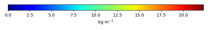
Period Mean (original grids) [Pg] |
Model Period Mean (intersection) [Pg] |
Benchmark Period Mean (intersection) [Pg] |
Model Period Mean (complement) [Pg] |
Benchmark Period Mean (complement) [Pg] |
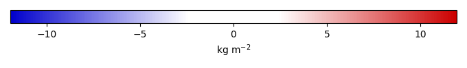
Bias [kg m-2] |
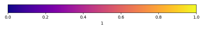
Bias Score [1] |
Spatial Distribution Score [1] |
Overall Score [1] |
|||
|---|---|---|---|---|---|---|---|---|---|---|---|---|
| Benchmark | [-] | 26.2 | ||||||||||
| CABLE-POP | [-] | 444. | 20.7 | 25.2 | 424. | 0.952 | -0.577 | 0.583 | 0.630 | 0.606 | ||
| CARDAMOM | [-] | 408. | 26.9 | 25.3 | 381. | 0.841 | 0.194 | 0.755 | 0.909 | 0.832 | ||
| CLASSIC | [-] | 601. | 30.9 | 26.0 | 567. | 0.130 | 0.595 | 0.587 | 0.843 | 0.715 | ||
| CLM6.0 | [-] | 978. | 37.3 | 26.2 | 931. | 1.29 | 0.626 | 0.867 | 0.747 | |||
| DLEM | [-] | 482. | 17.7 | 25.8 | 464. | 0.342 | -1.03 | 0.622 | 0.616 | 0.619 | ||
| ED | [-] | 343. | 10.2 | 25.9 | 332. | 0.276 | -1.97 | 0.526 | 0.413 | 0.469 | ||
| ELM | [-] | 817. | 37.1 | 26.1 | 773. | 0.0852 | 1.33 | 0.624 | 0.898 | 0.761 | ||
| IBIS | [-] | 323. | 15.0 | 25.8 | 308. | 0.349 | -1.37 | 0.638 | 0.628 | 0.633 | ||
| iMAPLE | [-] | 416. | 23.5 | 26.2 | 392. | -0.330 | 0.656 | 0.899 | 0.777 | |||
| ISAM | [-] | 708. | 45.3 | 25.8 | 662. | 0.342 | 2.47 | 0.530 | 0.728 | 0.629 | ||
| ISBA-CTRIP | [-] | 671. | 42.4 | 26.2 | 628. | 0.00893 | 1.98 | 0.552 | 0.742 | 0.647 | ||
| JSBACH | [-] | 374. | 18.9 | 25.3 | 353. | 0.852 | -0.774 | 0.593 | 0.823 | 0.708 | ||
| JULES | [-] | 388. | 9.48 | 26.2 | 379. | 0.00305 | -2.03 | 0.520 | 0.584 | 0.552 | ||
| LPJ-GUESS | [-] | 324. | 12.3 | 25.8 | 311. | 0.342 | -1.72 | 0.567 | 0.365 | 0.466 | ||
| LPJml | [-] | 572. | 27.8 | 26.2 | 544. | 0.00305 | 0.197 | 0.660 | 0.859 | 0.759 | ||
| LPJwsl | [-] | 608. | 27.2 | 25.8 | 580. | 0.342 | 0.173 | 0.693 | 0.849 | 0.771 | ||
| LPX | [-] | 439. | 17.4 | 26.2 | 421. | 0.0121 | -1.08 | 0.621 | 0.666 | 0.644 | ||
| OCN | [-] | 541. | 20.1 | 25.7 | 521. | 0.427 | -0.704 | 0.655 | 0.739 | 0.697 | ||
| ORCHIDEE | [-] | 383. | 16.1 | 26.2 | 367. | 0.00305 | -1.23 | 0.609 | 0.555 | 0.582 | ||
| SDGVM | [-] | 477. | 26.8 | 26.0 | 451. | 0.149 | 0.0906 | 0.633 | 0.876 | 0.754 | ||
| VISIT | [-] | 477. | 23.2 | 25.6 | 454. | 0.543 | -0.306 | 0.611 | 0.847 | 0.729 | ||
| VISIT-UT | [-] | 482. | 21.4 | 25.6 | 461. | 0.543 | -0.544 | 0.595 | 0.859 | 0.727 |
Temporally integrated period mean